

Between November 2022 and April of this year, the Brazilian Navy carried out hydrographic surveys in the region of Estreitos de Breves and in the Melgaço, Portel and Bocas Basins, in the Marajó Archipelago, regions of intense waterway traffic in Pará. The depths of access channels, maneuvering areas, anchoring and mooring berths in a perimeter of about 500 km² were recorded. The data obtained in the field form the basis for the creation of unprecedented nautical charts for the area, which only has a navigation sketch.
Marajó’s nautical charts, 4341 and 4342, are provided for in the III Brazilian Nautical Cartographic Plan, published by the Navy’s Directorate of Hydrography and Navigation (DHN). “The continuous hydrographic survey of the rivers requires planning and a considerable logistical effort, with a view to increasing navigation safety. The Navy has been investing human, material and financial resources in the activity, which will result in the delivery of new nautical charts to society, essential for a region that uses rivers as if they were roads”, evaluates Vice-Admiral Antônio Capistrano de Freitas Filho, Commander of the 4th Naval District.
The soundings were carried out by means subordinate to the Center for Hydrography and Navigation of the North: the River Hydrographic Warning “Rio Tocantins” and the Beacon Warning “Denébola”, both equipped with a single beam echo sounder for sounding, in addition to the Inland Waters Hydrographic Boat “Rígel” , who provided logistical support. The hydrographic surveys in Marajó were carried out in partnership between the Brazilian Navy and the National Department of Infrastructure and Transport.
With about three thousand islands and islets, Marajó is the largest fluvio-maritime archipelago in the world. Located at the confluence of the Amazon and Tocantins-Araguaia rivers, it is home to the Amazon estuary, one of the richest regions in the country in terms of water and biological resources.
The archipelago covers 16 municipalities: Afuá, Anajás, Bagre, Breves, Cachoeira do Arari, Chaves, Curralinho, Gurupá, Melgaço, Muaná, Ponta de Pedras, Portel, Salvaterra, Santa Cruz do Arari, São Sebastião da Boa Vista and Soure. The total area of the archipelago, 104,139.93 km², is greater than the sum of the territories of the states of Espírito Santo and Paraíba. The population is estimated at 557,231 inhabitants.
Larger commercial vessels, in addition to barges, will benefit. “The production of nautical charts in the region of the Straits constitutes a relevant increase in navigation safety, especially due to the intense vessel traffic, contributing greatly to ordering the flow of this route, which is so significant for Arco Norte. security, the riverside population also benefits directly from this initiative, since navigation is the main means of transporting cargo and people in the areas covered by the new charters that will come into force”, assesses Wellington Guanabara, Navigation Manager at Hidrovias Brasil, logistics solutions company that operates in waterway transport and also navigates in the region being mapped.
What is a hydrographic survey?
Hydrographic survey is a set of activities carried out to obtain bathymetric, geological, tidal, fluviometric, geodetic, oceanographic and geophysical topo data, in maritime, river, lake and natural or artificial channels.
Modern echo sounders use the physical principles of sound propagation in water to calculate depth. The signals from an echo sounder are emitted by a source towed on the surface or fixed to the hull of the vessel. High-frequency acoustic waves propagating through water reach the bottom and are reflected back to the surface. Obtaining the speed of propagation of sound in water and the transit time of the signals, it is possible to calculate the depth.
What are nautical charts?
Nautical charts are representations of the earth’s surface, which allow the navigator to orient himself on his position and dangers (banks, submerged stones, capsized hulls or any other obstacle), depths and aids that allow safer navigation.
Depth records are essential for accurately determining the clearance below the keel of vessels, that is, the distance between the deepest point of the ship’s hull and the bottom of the river. In Brazil, all official nautical charts are produced and updated by DHN.
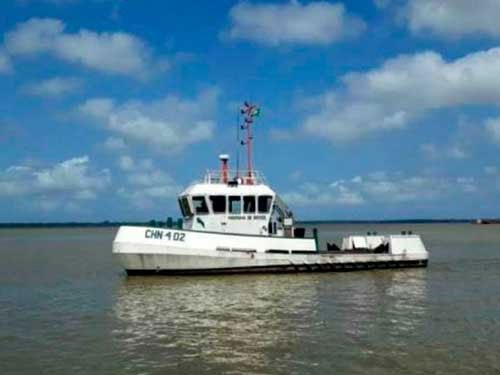
Get to know the naval assets that participated in the surveys

 The Fluvial Hydroceanographic Notice “Rio Tocantins” has a length of 25 meters and a mouth (width) of 6.5 meters. It is equipped with a dual-frequency single-beam echo sounder and weather station. Its crew consists of 18 military personnel.

The “Denébola” Beacon Warning is used in nautical signaling. Its length is 20 meters and its mouth measures six meters. It holds up to seven crew members and has autonomy to navigate for a week, without the need for stops for refueling.