
There were more than 1 million and a half square nautical miles explored and about twenty hours of flight to identify each of the vessels that are operating in this area.
Rapa Nui. In the constant work of the Navy to keep the jurisdictional waters safe, between September 5 and 7, the Oceanic Fisheries Control Operation (OFPO) “Mata Hui 3” was carried out by the P-3 “Orion” aircraft, belonging to the VP-1 maritime air exploration group of the Naval Aviation.
The tasks developed by this aircraft allowed to monitor in real time the surface panorama over the marine park “Motu Motiro Hiva”, where it was possible to identify a fleet of 23 foreign fishing vessels that was 700 nautical miles east of Rapa Nui, that is, almost one thousand 300 kilometers to the continent from this island territory, but outside the Chilean Exclusive Economic Zone (EEZ).
With 1,656,600 square miles explored and 19 hours of flight, the crew of the aircraft led by its Commander, Lieutenant Commander Michael Richter, is prepared to perform this type of tasks that require high concentration and teamwork.
The plane
The P-3 “Orion” is an aircraft designed in the sixties by the American company Lockheed Martin and that fulfills, according to Captain Richter himself, with great versatility. “It is an aircraft that fulfills – in times of war – mainly tasks of anti-submarine warfare and in times of peace aeromaritime exploration,” said the Captain.
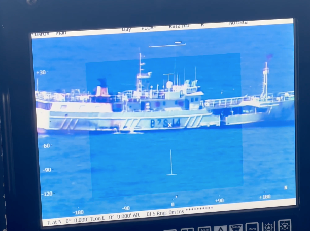
In this way, one of its most important qualities is the FLIR camera, designed to obtain images in high resolution, infrared and with heat zones. In the OFPO, this device allows to register in the best possible quality the registration number or visualize if there are people on deck, among other functions.
Second Corporal Valentina Godoy is part of the P-3 crew and a member of the VP-1 squadron of the Naval Aviation; her tasks as a navigator include, in her words, “compiling the surface panorama of the fishing fleet and then being sent to the Units that are operating together with us.”
OFPO: a contribution to maritime security and interests
“Control and verify that the real surface panorama is consistent with the control we have at the national level in our databases,” is how OFPO “Mata Hui 3” describes First Corporal Christian Muñoz, of the Department of Maritime Traffic Control of the Directorate of Security and Maritime Operations of the Navy (DIRSOMAR); this is the main function of the OFPO together with identifying and reporting on vessels operating beyond the EEZ, in addition, they have the task of ensuring compliance with current treaties on the conservation of marine flora and fauna signed by the State of Chile.
In this line, the Commander in Chief of the Navy, Admiral Juan Andrés De la Maza, stressed the importance of confirming what is displayed through satellite positioning systems in the situation room of the General Directorate of Marine Territory and Merchant Marine (DIRECTEMAR) with what the aircraft can observe in the same sea, reflecting the existing commitment of the Maritime Authority to ensure the safety of the EEZ.
In addition, Admiral De la Maza himself mentioned that the Navy “makes available all the institutional means to the State to execute the tasks that traditionally correspond to us according to the Mission Areas and specifically to the most important Mission Area that the Navy has, which is Territorial Integrity, that is, the security of our territory. All institutional means, in their versatility, can contribute to fulfill other Mission Areas.”
Finally, it should be noted that the presence of the Chilean Navy in jurisdictional waters reaffirms the ability to be a State agency with a high technological development that seeks to protect areas of national interest, marine flora and fauna, and the safeguarding of human life at sea.