
From 10 to 17 December, the research vessel Belgica will sail along our North Sea coast with several scientists on board. Among them is Sonia Papili, researcher for the Marine Component and the Royal Military Academy. She conducts research along our coast with the aim of fully mapping the seabed in order to arrive at innovative solutions for combating sea mines.
The new Defense mine countermeasures vessels, the first of which is expected to be delivered in 2024, will be equipped with unmanned autonomous systems containing state-of-the-art acoustic, magnetic and/or optical sensors. A better overview of the underwater environment is indispensable for the autonomous operation of these different unmanned vehicles and for the evaluation of the performance of their sensors.
During this project, Sonia Papili was assisted by two soldiers from the Marine Component, Pieter-Jan and Geoffrey. Together they used different techniques in several places to map the seabed of our coast. These sites were chosen because of their strategic economic location and the potential risk associated with mine countermeasures.
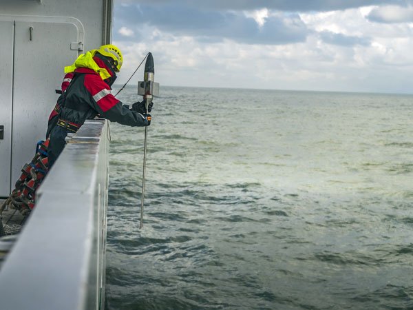
Free Fall Sting
Geoffrey hangs over the side of the ship holding something that looks like a torpedo, connected by a long rope. “This is the Sting,” he says. This freefall penetrometer (a bottom probe with an enormous measuring range) is dropped vertically into the water in order to register the carrying capacity of the seabed. “When a sea mine lands on the bottom, we can use this tool to estimate the likelihood that the mine is buried,” says Geoffrey. “That is why we measure this carrying capacity in various places.”
Box Coring
“With this device we can take vertical samples from the first 20 to 30 cm of the seabed without disturbing the sediment,” explains Sonia while a first piece of seabed is lifted up with the crane. This is called box coring. “Once we have scooped the water out of the iron pipe, we will take a sample for the laboratory,” explains Pieter-Jan.
For the lab sample, a narrow plastic tube is carefully placed vertically in the piece of seabed and then manipulated as little as possible to close the tube. “We want the picture to be as fair as possible, so it’s important not to shake it too much or tilt it,” says Sonia.
The surrounding sediment is then subjected to a first analysis. “We look at the different layers that make up the seabed, the sediment composition, and describe them according to color and structure. This gives us a first idea of how deep a sea mine can sink,” says Sonia as she rubs a layer of mud between her fingers, studies it and notes the result. It is then thoroughly examined in the lab for particle size and biological activity, among other things.
Multibeam and sub-bottom profile
On a map, a zone of the North Sea is divided into different lines. The intention is that the navigator of the ship sails as perfectly as possible over these lines. At the bottom of the ship there are 2 types of sonar that emit acoustic signals and whose reflection is measured. “In this way we scan the seabed horizontally and also take a vertical profile of the seabed and then map it. A 3D drawing of the seabed is, as it were, made. This way we know where there are dunes, where it is flat or where there are only ripples,” explains Sonia.
Finally, these data will be combined and compared to obtain a good picture of the characteristics of the test zone. “In the future, we will image two or three other test zones in the same way, resulting in a good understanding of the seabed of the entire coastline.”